Tropical Storm Nicholas Seen to Strengthen, Affecting Texas and Louisiana With Heavy Rains Weeks After Hurricane Ida
Tropical Storm Nicholas is moving toward the Texas coast on Sunday night, bringing heavy rain and floods to coastal areas of Texas, Mexico, and Louisiana.
The National Hurricane Center in Miami had issued a hurricane watch for the central part of the Texas coast, with the state's coastline now under a tropical storm warning, according to an NPR report.
Up to inches of rainfall was forecasted to be poured down in Texas and Southwest Louisiana, with isolated maximum amounts of 20 inches across coastal Texas areas.
Meanwhile, Texas Gov. Greg Abbott had deployed rescue teams and emergency medical groups on standby along the Texas Gulf Coast.
Abbott said that they will continue to monitor this storm and take all precautions needed.
He then called Texans to adhere to the guidance and warnings of their local officials and beware of heavy rain and flooding.
READ NEXT : Alligator Attack: Lousiana Man Killed by Alligator While Wading Through Hurricane Ida Floodwaters
Louisiana and Tropical Storm Nicholas
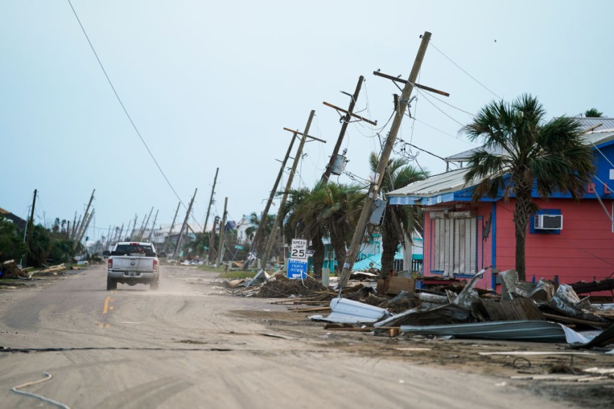
Daily Mail reports the heaviest rainfall is expected to hit west of where Hurricane Ida had ravaged Louisiana just over a week ago.
Forecasters did not project Louisiana to experience strong winds again. But meteorologist Bob Henson predicted that rainfall could still be poured down on places where Hurricane Ida affected homes.
Henson also said heavy rain could also affect areas with paralyzed electrical and water services.
About 6.3 percent of the state or 140,198 residents remained without power, according to the Louisiana Public Service Commission.
Meanwhile, Louisiana Gov. John Bel Edwards urged people in the southern area of the state to be wary of the storm and prepare for heavy rains and flash flooding.
Edwards said that it is likely to see heavy rain particularly in the areas recently affected by Hurricane Ida, according to a Black Hill Fox report.
Meteorologist Donald Jones of the NWS in Louisiana said that the storm is projected to move slowly up to the coastland, which could pour torrential amounts of rain for several days.
Jones said that heavy rain and flash floods appear to be the biggest threat across the region.
Hurricane Ida
Hurricane Ida's rampage at the state of Louisiana had dramatically altered the coastline, according to satellite images of Louisiana taken before and after.
Many low-lying areas are still submerged with water. Scientists are carefully monitoring the landscape to see how it changes over time, whether some changes will be permanent, according to a Gizmodo report.
In addition, the hurricane had also reportedly reshaped the landscape, although it was not yet certain for how long.
NASA's Earth Observatory noted that other human activities, including the pumping of groundwater and oil, had also contributed to this development.
Images from space taken before and after the hurricane had also shown that there was a change in the river delta.
Floodwaters were still present five days after the storm, with rivers, coastlines, lakes, and marshes being barely recognizable.
Marc Simard, a principal investigator for NASA's Delta-X mission, said that the combination of flooding, erosion, defoliation during the hurricane likely created the new patches of open water.
READ MORE: Tornado Warning Issued in Chicago, With the Tornado Reportedly Touching Down in Dekalb County
This article is owned by Latin Post
Written by: Mary Webber
WATCH: Tropical Storm Nicholas and Tropical forecast update; September 12, 2021 - from FOX 13 Tampay Bay
Subscribe to Latin Post!
Sign up for our free newsletter for the Latest coverage!
© 2026 Latin Post. All rights reserved. Do not reproduce without permission.


