Hurricane Lee Path and Updates: Where Is the Category 4 Storm Heading?
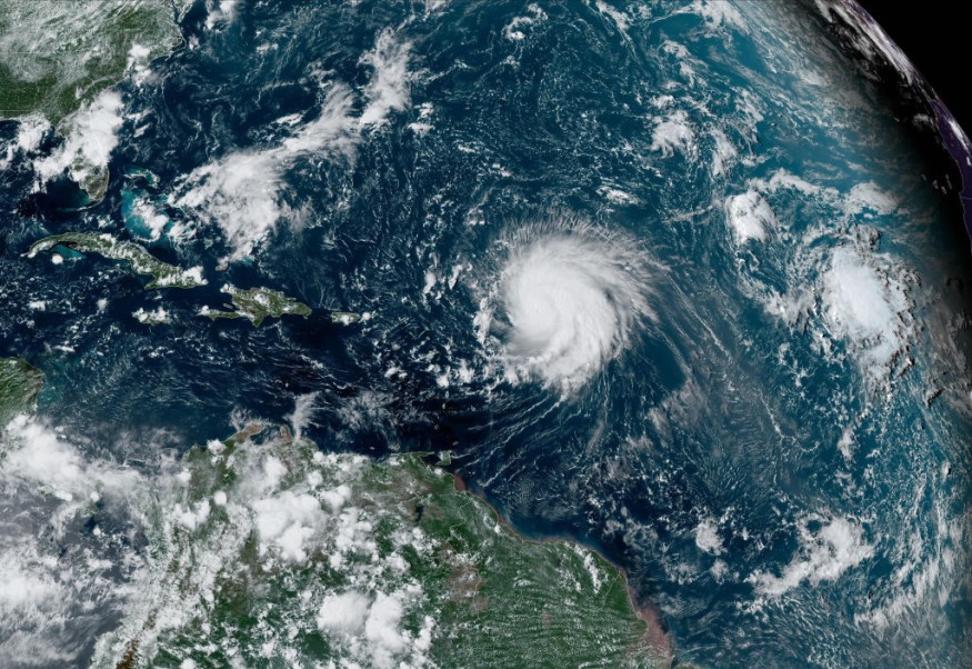
Hurricane Lee has now strengthened to a rare Category 5 hurricane out in the Atlantic and is still getting stronger. However, its path remains a toss-up as the National Hurricane Center (NHC) stated that it is still too early to predict where it will go.
The hurricane previously weakened a bit before gaining more strength and turning into a Category 5. It is strengthening at a "historic pace," according to CNN, and it is now packing maximum sustained winds of 155 mph. It is currently 550 miles east of the northern Leeward Islands.
"Although Lee's current intensity is lower than the overnight peak, the hurricane remains very powerful," said the NHC in a statement. The agency added that "more slight fluctuations in maximum winds are expected over the next several days."
Lee first became a Category 1 hurricane last Thursday but soon intensified quickly as it went through the warm ocean waters of the Atlantic Ocean. It was recorded to have doubled its wind speed within just a day, increasing by 85 mph in a 24-hour period.
Hurricane Lee is now tied with Hurricane Matthew as the third-fastest rapid intensification in the Atlantic. Matthew struck Haiti in 2016 and killed hundreds of people before wreaking havoc in the US Southeast.
Hurricane Lee Remains an 'Extreme Risk' to US East Coast Beaches
Hurricane Lee is still hundreds of miles from land but may hit land soon as millions in the Caribbean and the Eastern US are already bracing themselves for what to do in case it does make landfall.
According to USA Today, Hurricane Lee is forecasted to continue moving west-northwestward, with its path expected to take it somewhere northeast of the Turks and Caicos Islands and the eastern Bahamas on Tuesday. However, it is still unknown whether it will hit Florida or the US East Coast.
READ MORE : Hurricane Lee Now a Category 4 Hurricane, Caribbean Braces For Impact and US East Coast Might Get Hit
"There's absolutely no indication in front of us that this is going to be a huge threat to Florida, other than it's going to be a huge rip current risk," NHC Deputy Director Jamie Rhome told USA Today. "Right now, save the rip current risk, which is extreme, there's no reason for people on the East Coast to be fearful."
The NHC is warning that "Rough surf, rip currents, and hazardous conditions are forecast along much of the U.S. East Coast starting as early as Sunday evening." In addition, very large waves are expected to hit the US East Coast by Tuesday and Wednesday.
Hurricane Lee Remaining Powerful
Hurricane Lee is continuing to move west as its strength continues to fluctuate from Category 5 to Category 4 strength and then back again. It is expected to continue being a powerful major hurricane as it makes its way through its path that may or may not take it to the US mainland.
Hurricane Lee is expected to affect the British and US Virgin Islands, Puerto Rico, Haiti, the Dominican Republic, the Bahamas, Bermuda, and Turks and Caicos, according to NBC News.
As for the US, it might not make landfall in the country due to the Bermuda High, a high-pressure area that may take the storm northeast to Florida or north to Canada.
This article is owned by Latin Post.
Written by: Rick Martin
WATCH: Hurricane Lee Continues To Churn As Category 4 Storm In Atlantic - FOX Weather
Subscribe to Latin Post!
Sign up for our free newsletter for the Latest coverage!
© 2026 Latin Post. All rights reserved. Do not reproduce without permission.


