Tropical Storm Beta Makes Landfall on Texas Coast Late Monday
Tropical Storm Beta made landfall on the Texas coast around 10 p.m. (CDT) Monday, as said by the National Hurricane Center (NHC).
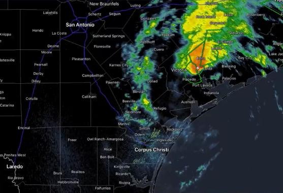
Beta made landfall near the southern end of the Matagorda Peninsula in the southeastern coast of Texas, reported CNN. It sits between Corpus Christi and Galveston and is along the Gulf of Mexico.
The Associated Press said in a report that Beta's maximum sustained winds were at 45 mph. The storm's winds also weakened after landfall.
The NHC said that storm surge was up to five feet from San Luis Pass to Sabine Pass in Texas. The Texas Department of Transportation said in a tweet late Monday that parts of State Highway 87 were not passable due to flooding.
Storm Warnings Remain
"There is the danger of life-threatening storm surge near times of high tide through Tuesday along portions of the Texas and Louisiana coasts," the NHC said. The NHC also added that up to 15 inches of rain could fall in some areas.
"This rainfall can lead to significant flooding, which may last for several days," AccuWeather senior meteorologist Rob Miller said.
Tropical storm warnings are still in place in some parts of Texas and Louisiana coastlines. But the main threats posed by Beta are still possibilities of storm surge and heavy rainfall.
A storm surge warning is in place at the Port Aransas to Sabine Pass area. This includes Copano Bay, Aransas Bay, San Antonio Bay, Matagorda Bay and Galveston Bay.
There were also flash flood watches placed in all of the Texas and Louisiana Coasts. This covers nearly 11 million people under the warning.
Amount of Rain Still Uncertain
Forecasts are still uncertain about the amount of rainfall that the tropical storm can produce. Some areas have already seen some damage during the busy hurricane season and are weary about the threats of Beta.
Its slow-moving approach could lead to long periods of rain, causing flash, urban and river flooding, said the NHC.
Dan Reilly, a meteorologist with National Weather Service Houston-Galveston said the rainfall is the "probably most uncertain part."
Earlier forecasts on Beta showed up to 20 inches of rain in some areas. But the number was pulled down to 15 in some locations.
The coastal counties were found to get about four to six inches. It is possible for rainfall to go down to two to four inches as the storm moves further inland, Reilly said.
Rain has already fallen in Houston and other southern parts of the Texas coast on Monday, even Beta made landfall.
With the warnings of heavy rainfall also comes assurance from officials and forecasters. They said Beta is not expected to be another Hurricane Harvey that dumped more than 50 inches of rain on Houston in 2017.
It is also unlikely to be another Tropical Storm Imelda that hit Southeast Texas last year. It was said to be one of the wettest cyclones on record.
As Tropical Storm Beta moves inland, it is expected to move slower and take a sharp turn to the north-northeast on Tuesday.
It will still stay close to the coast of southeastern Texas until Wednesday. After this, it is believed to drench Arkansas, Texas and Louisiana area and move into Lower Mississippi Valley. Later into the week, it will also move to the southeast.
Check these out!
Tropical Storm Beta to Drench Texas Coastline Next Week
Tropical Storm Sally Forms Near Florida
Hurricane Sally Slams into Florida and Alabama; Rescues Underway for Widespread Flooding
Subscribe to Latin Post!
Sign up for our free newsletter for the Latest coverage!
© 2026 Latin Post. All rights reserved. Do not reproduce without permission.


